 Introduced in 2005, Google Earth is a three-dimensional virtual globe overlaid with dynamic data layers that let you explore land, oceans, moon and stars. There’s even a tour guide option that will give you historical information about significant places and events.
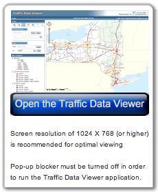
Governments and businesses are using it to make decision for location based projects by analyzing geospatial information layered by topographic, demographic, traffic data, and the like. For example, the New York State Department of Transportation has developed a Traffic Data Viewer that uses data from the National Geodetic Survey (NGS) Database (a google earth application) to display published traffic data graphically. County administrators can use this resource to plan repaving efforts or an entrepreneur could use local traffic patterns to determine the best location to open up their new start-up.
 Educators are using it extensively in many different disciplines and ways, such as understanding global development, selecting and visualizing field study sites, studying land-use law and to depict the locations of many of the disputes, visualizing historical events and issues like the Trans-Atlantic slave trade routes, the underground railroad, the abolishment of slavery in Great Britain, mapping field trip routes, analyzing communication systems and so much more.
Plus, the Google Earth community is a great place to find data and can be used to explore historic grave sites, find overlays and place-marks related to Hurricane Katrina and the subsequent flooding in New Orleans, study locations of large airliner accidents, shipwrecks, World War I & II, and more.
Feel free to leave us a comment because we want to know… How have you been using Google Earth?